Reflections on Mapping the South March Highlands Kanata Lakes Trails
For purposes of simplicity, although both trail systems are within the South March Highlands, I will refer to these trails, across from the Goulbourn Forced Road (GFR) parking lot, as the KL trails and the ones in the Conservation Forest as the SMH trails.
On Wednesday (May 25, 2011) I started my latest mapping project of what mountain bikers refer to as the Kanata Lakes trails, to distinguish them from the trails within the South March Highlands Conservation Forest. I do this either with a sense of history or a sense of optimism because these trails are located in Phase 7 of the KNL/Urbandale Destruction and are planned to be destroyed along with the forest and geology they are part of, to be replaced with yet another ticky tacky suburban subdivision.
Need I say one more time that losing this land and these trails will be a real tragedy, and indeed the Terry Fox Drive extension (routed over the least environmentally friendly route after public consultations indicated environmental factors should be the first priority in route selection) has already had a devastating effect on the natural and trail connectedness in the South March Highlands. Nevertheless as we fight to save what is left we should enjoy it for as long as we can and hopefully this trail map, when completed, will contribute to that.
As with any mapping exercise I start I quickly discover the trail system is more complicated than I thought and includes more trails than on any existing map. So this is going to take a few rides to complete. At the moment I have tracks from this ride (blue) and another from last summer (red) on the very preliminary map below.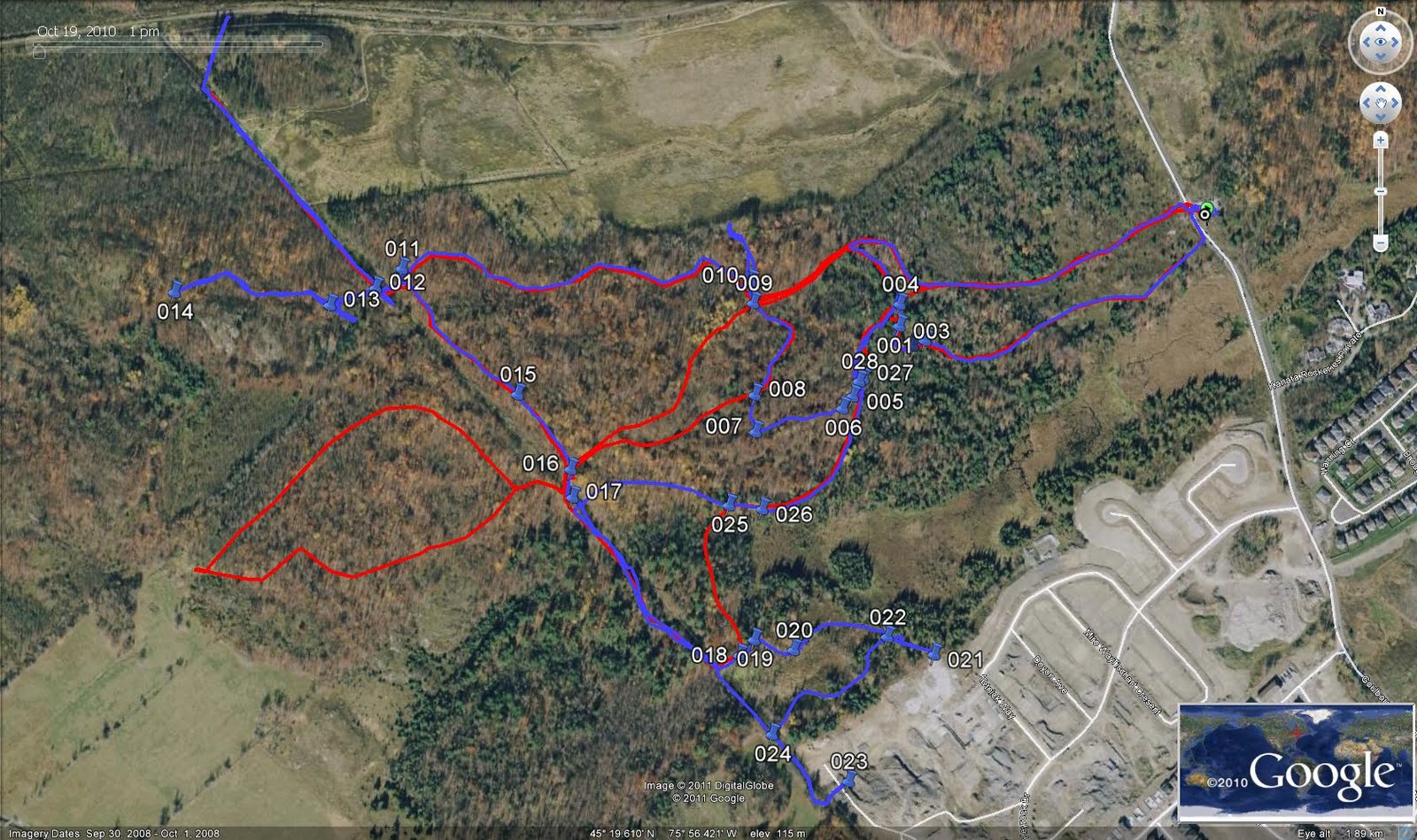
As there did not appear to be any visible trail left at the old Kizell Pond signpost, I thought I would go in from the "Race Track Entrance" (that is not the entrance right across from the parking lot, but a bit south of it where you go "through" a couple of rocks) and see if I could work my way out to the signpost.
I never did get there but I did follow the hydro cut all the way to it's southeast end and discovered it ends in the Kizell Pond Subdivision. In the process I discovered a little loop around part of Kizell Pond, that might provide a pleasant route for short nature hikes with easy access. That was the first time I followed the hydro cut all the way to that end.
I also followed the hydro cut all the way to the northwest end where it ends at the Terry Fox Drive extension close to where it used to cross the rail line. As there was construction going on, and operating equipment right in my route to the other side, I was not able to confirm if you can access the other side. Depending on the gulley along the rail line you should be able to cross Terry Fox Drive at the rail line (traffic permitting) and connect to the rest of the trails.
The other interesting thing I discovered was another open section of trail (blue) west of the hydro cut on "The Dark Side", in addition to the section (red) I discovered open last summer. "The Dark Side" was private land that was fenced in and biking was prohibited on. Some of it is now city land but the status of these sections would require a very careful map comparison/overlay to determine. Both of these sections end at the new Terry Fox Drive extension.
The rest of my mapping experience consisted of following the usual KL trails including one offshoot that leads to a big open field where you can see the rail line across on the other side. If you follow the preliminary map above with these descriptions you should be able to see where much of what I am talking about is.
So why is this land and these trails so important. Very briefly, the South March Highlands is the most bio-diverse area in Ottawa and we are very fortunate to have such an area within our city and so close to the urban area. But, being surrounded by urban land puts its ecological integrity under great stress and if we continue to develop important pieces of it not only do we reduce its size but we increase the outside stresses on the land. We are close to the point of it's losing it's ecological integrity.
But this post is about the trail system and the KL trails have their own character distinct from the SMH trails. For mountain biking much of these trails are at an easier level and more open to riding by beginners. The terrain differences also make these trails much better suited to cross-country skiing than the SMH trails, which are better suited to snowshoeing. The two trail systems complement each other very well and are part of one interconnected ecological system, even with Terry Fox Drive running through the heart of them.
There is one distinct difference between the two systems. The KL trails are older and most were built by hikers and cross-country skiers while many of the SMH trails were by built by mountain bikers and are being maintained by them. It is very obvious that the SMH trails are much more sustainable than the KL trails. If we are successful in saving the KL trails there will need to be a review of the trails, which can probably be done as part of the City of Ottawa - OMBA (Ottawa Mountain Bike Association) joint stewardship agreement that is expected to be signed soon. Much work will need to be done to bring them up to OMBA standards. possibly including rerouting or closing some sections of trail.
But for now I hope to just finish mapping the trails so that we know what is there and can all enjoy the wonderful experience of being in this forest that we all hope to enjoy forever.
Now if we could just get the decision makers to spend a day in this wonderful forest.

